Observing Tools
Double-sided Planisphere
 to Japanese/“ú–{Śę‚Ö
Written by Toshimi Taki
January 5, 2003
Rev. A: January 11, 2003
Rev. B: October 30, 2011
== Double-sided Planisphere -- Sky Map ==

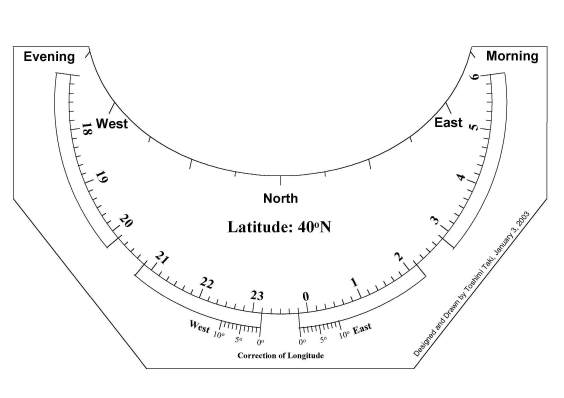
== Cover -- Northern Horizon ==
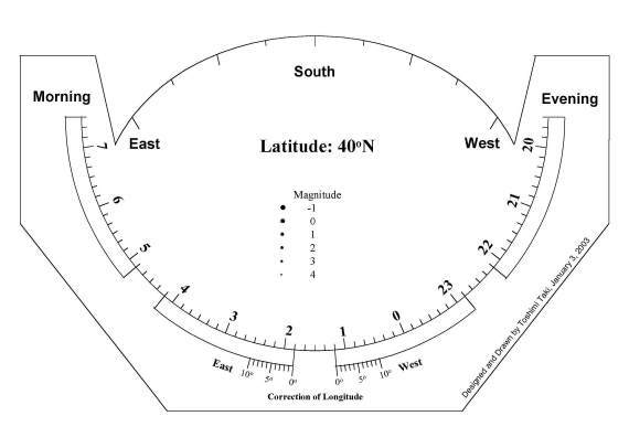
== Cover -- Southern Horizon ==
Design Feature
Double-sided planisphere presented here is based on the design by Mr. Yasuo Hirasawa, who is an avid member of Oriental Astronomical Association in Japan. Planisphere of the similar design is supplied commercially as "The Night Sky" by David Chandler.
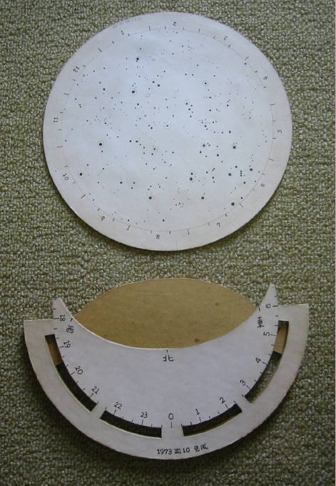
I made a similar planisphere myself 30 years ago. See photographs below. It was very useful and I used it for many years. This is the reason why I reproduce a new double-sided planisphere.
== Double-sided Planisphere I made in 1973 ==

== Sky Map and Cover ==
The double-sided planisphere has following features.
(1) Distortion near Southern horizon is smaller than common planisphere (one-sided planisphere).
(2) You can remove a sky map from a cover and you can use it as a all sky map.
(3) If you have covers for the other latitudes, you can use the planisphere everywhere in the world.
(4) You can write your memo on the sky map because the sky map is not covered.
(5) Correction for longitude difference is possible.
(6) Position of the Sun is plotted on the sky map and you can find approximate time of sunrise and sunset.
Sky Map
Data of stars is based on Hoffleit E.D., Warren Jr. W.H., "The Bright Star Catalogue, 5th Revised Ed. (Preliminary Version), " Astronomical Data Center, NSSDC/ADC (1991). Stars up to 4.5 visual magnitude are plotted on the sky map.
I prepared 2 kinds of sky maps. One is a basic sky map on which only stars are plotted. You can plot your constellation lines. Constellation lines are plotted on another sky map. No deep sky objects are plotted on the sky maps. You can plot your favorite objects on the map. Names of constellations or stars are not printed either. Make your own sky map with adding your favorite information.
Mr. Sizhuang Liu from China added the constellation names (in Latin and in Chinese) on the maps.
I used MS-Excel and MS-Powerpoint to produce the sky map and covers. Calculations were made in MS-Excel and then the data were plotted in MS-Powerpoint.
Files
Following files are available. All files are in pdf format for A4 size.
Download dbl_side.zip and exract it. Print a sky map file, spacer file and file(s) of cover plates on white papers. You can enlarge the size when you print if you would like to have larger sky map. Make sure that all the prints are enlarged in the same size.
Click here to download "dbl_side_a.zip" (527KB).
Click here to download "sky_map_latin.pdf" (168KB).
Click here to download "sky_map_chinese.pdf" (235KB).
Content of dbl_side_a.zip
=================================================================
Sky Map without Constellation Lines:		sky_map_basic.pdf
Sky Map with Constellation Lines:		sky_map.pdf
Spacers:					spacer.pdf

Cover Plates for Latitude  0 degree North:	cover_0.pdf
Cover Plates for Latitude  5 degree North:	cover_5n.pdf
Cover Plates for Latitude 10 degree North:	cover_10n.pdf
Cover Plates for Latitude 15 degree North:	cover_15n.pdf
Cover Plates for Latitude 20 degree North:	cover_20n.pdf
Cover Plates for Latitude 25 degree North:	cover_25n.pdf
Cover Plates for Latitude 30 degree North:	cover_30n.pdf
Cover Plates for Latitude 35 degree North:	cover_35n.pdf
Cover Plates for Latitude 40 degree North:	cover_40n.pdf
Cover Plates for Latitude 45 degree North:	cover_45n.pdf
Cover Plates for Latitude 50 degree North:	cover_50n.pdf

Cover Plates for Latitude  5 degree South:	cover_5s.pdf
Cover Plates for Latitude 10 degree South:	cover_10s.pdf
Cover Plates for Latitude 15 degree South:	cover_15s.pdf
Cover Plates for Latitude 20 degree South:	cover_20s.pdf
Cover Plates for Latitude 25 degree South:	cover_25s.pdf
Cover Plates for Latitude 30 degree South:	cover_30s.pdf
Cover Plates for Latitude 35 degree South:	cover_35s.pdf
Cover Plates for Latitude 40 degree South:	cover_40s.pdf
Cover Plates for Latitude 45 degree South:	cover_45s.pdf
Cover Plates for Latitude 50 degree South:	cover_50s.pdf
=================================================================
Instruction for Assembly
Note: Don't use waterbase glue or paper will wrinkle.
(1) Glue the spacers on a cardboard. Cut out the two spacers.
(2) Glue the northern sky map on a cardboard. Cut out the sky map. Cut out the southern sky map and glue it onto the opposite side of the northern sky map. Be sure that the triangles on both the northern and the southern sky maps are in the same place on the perimeter of the circle.
(3) Glue the northern cover plate on a cardboard and cut out the cover. Cut out the windows for date/time reading, too.
(4) Glue the southern cover plate on a cardboard and cut out the cover. Cut out the windows for date/time reading from the cover plate.
(5) Sandwich the spacers between the cover plates with glue.
(6) After glue is dried out, insert the sky map in the cover.